The best wall maps for science lessons make complex ideas easier to see, discuss, and remember. This roundup compares 10 options across scale, detail, durability, and classroom usefulness.
Whether you need a large world reference, a physical map for Earth science, or a versatile map set for a shared learning space, the right choice depends on your room, curriculum, and display needs.
Best 10 Wall Maps for Science Lessons Picks for 2026
Classroom Giant

- 46-by-80-inch display
- Write-on, wipe-clean laminate
- Updated political detail
Best For: Large classrooms and interactive geography lessons
Earth Systems Focus
National Geographic Physical World Map
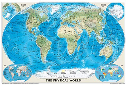
- Emphasizes land and undersea forms
- Includes crust and climate insets
- Uses Winkel Tripel projection
Best For: Physical geography and Earth science lessons
Flexible Pair
Laminated World and USA Map Set

- Includes world and USA posters
- Equal Earth relative-size design
- 3 MIL laminated and tear resistant
Best For: Compact classrooms needing two map perspectives
Reference Standard
National Geographic Executive World Map

- Detailed physical and political reference
- Includes four subject-focused inset areas
- Heavy-duty laminated finish
Best For: Detailed secondary-school and library reference
Best Value Pair

- Includes world and USA posters
- 18-by-29-inch display size
- 3-mil laminated and tear resistant
Best For: Classrooms needing separate world and U.S. map references
Best for Relief Detail

- 3D shaded relief for land and oceans
- 24-by-36-inch display size
- Folds to 8-by-10 inches
Best For: Geography lessons needing terrain context and portability
Best Two-Sided Reference
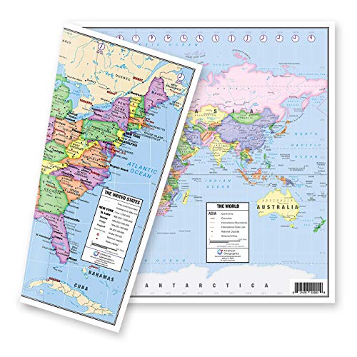
- U.S. and world maps on opposite sides
- Includes capitals, cities, and time zones
- 5-mil double-sided lamination
Best For: Students and compact classroom or home study spaces
Best Large Map Set
Classic World & USA 3D Wall Maps

- Two 24-by-36-inch maps
- Laminated and dry-erase compatible
- 3D terrain relief
Best For: Large classroom geography displays
Best Multitopic Set
World, USA & Solar System Posters

- Three educational posters
- Includes geography and astronomy topics
- Laminated and dry erasable
Best For: Younger learners and compact teaching spaces
Best Simple Reference
Laminated Blue World Map Poster

- Single world map poster
- 18-by-29-inch listed format
- Matte laminated finish
Best For: Basic world geography reference
Classroom Giant – 2026 Mega World Map
Giant World Map - Mega-Map Of The World 46 x 80 - Laminated - 2026 Updated | Maps International
Check Price On AmazonFor classrooms that need a highly visible reference, this giant laminated map is one of the most substantial wall maps for science lessons. Its 46-by-80-inch format provides room for country, city, and geographic detail, while the matte, write-on surface supports interactive teaching.
Best For: Large classrooms, geography displays, and lessons that involve writing directly on the map.
Pros:
- Extra-large 46-by-80-inch size makes details easy to see from across the room.
- 2026 political map includes colored countries, towns, cities, and hill and sea shading.
- Laminated surface can be marked with whiteboard pen and wiped clean.
- Shipped rolled in a tube to help prevent creases.
Cons:
- The very large format requires substantial wall space.
- Its political focus may be less suitable when physical landforms are the main lesson objective.
This is the strongest choice when visibility and hands-on classroom use matter most. Its scale makes it a focal-point teaching aid, while the durable laminated finish supports repeated use.
Earth Systems Focus – National Geographic Physical World Map
National Geographic World Physical Wall Map (45.75 x 30.5 in) (National Geographic Reference Map)
Check Price On AmazonThis National Geographic physical map is a strong option for wall maps for science lessons centered on landforms, ocean-floor features, and climate. Its hand-painted relief emphasizes the Earth’s physical structure, and the two inset maps add context about crust and climatic zones.
Best For: Earth science units covering terrain, undersea forms, Earth’s crust, and global climate zones.
Pros:
- Highlights land and undersea forms with hand-painted relief.
- Winkel Tripel projection minimizes visual distortion.
- Includes inset maps for Earth’s crust and world climatic zones.
- 45.75-by-30.5-inch sheet offers a substantial wall display.
Cons:
- It is a physical map rather than a political reference, so country-boundary lessons may require another map.
- The supplied notes do not indicate lamination or a write-on surface.
Choose this map when physical geography is the priority. The relief styling and science-focused insets make it especially useful for explaining how land, oceans, crust, and climate relate.
Flexible Pair – Laminated World and USA Map Set
This two-poster set gives teachers a compact way to add wall maps for science lessons and geography activities. It pairs an Equal Earth world map, designed to show continents at true relative size, with an 18-by-29-inch USA map, and both posters receive tear-resistant 3 MIL lamination.
Best For: Smaller classrooms, study areas, and lessons that compare global and United States geography.
Pros:
- Includes both a world map and a USA map.
- Equal Earth design shows continents at true relative size.
- 3 MIL lamination adds durability and tear resistance.
- Compact 18-by-29-inch format is easier to place in limited wall space.
Cons:
- The smaller size provides less room for detailed labels than oversized wall maps.
- The supplied notes provide limited information about the USA map’s specific features.
This set is a practical value choice when you want two geographic perspectives without dedicating an entire wall to one oversized map. Its laminated construction should also suit regular classroom handling.
Reference Standard – National Geographic Executive World Map
For detailed reference displays, this National Geographic executive map is a polished option among wall maps for science lessons. It combines shaded relief, extensive physical and political labeling, and specialized inset maps in a 46-by-30.5-inch laminated format.
Best For: Secondary classrooms, libraries, and detailed lessons spanning physical geography, resources, population, and world regions.
Pros:
- Shows mountain ranges, valleys, water bodies, boundaries, cities, and other physical features.
- Corner insets cover vegetation, land use, population density, and polar regions.
- Winkel Tripel projection minimizes distortion.
- Heavy-duty 1.6 mil laminate improves durability and allows framing without glass.
Cons:
- The extensive information may be visually dense for younger students.
- Its 46-by-30.5-inch size is substantial but not as expansive as a giant classroom map.
This is the most information-rich selection in the group. It works well as a long-term reference because it combines authoritative-looking cartography, broad subject coverage, and a durable laminated finish.
Best Value Pair – Laminated World & USA Map Set
This two-poster set is a practical option for wall maps for science lessons when you want both world and United States geography in one purchase. Each 18-by-29-inch poster has 3-mil lamination for added durability and tear resistance.
Best For: Classrooms, homeschool spaces, and study areas needing separate world and U.S. map references.
Pros:
- Includes both a world map and a USA map.
- Generous 18-by-29-inch size for wall display.
- 3-mil laminated finish adds durability and tear resistance.
Cons:
- The supplied details do not specify additional features such as capitals, cities, or relief shading.
- Two posters require more wall space than a single map.
Choose this set if you want broad geographic coverage and durable laminated posters without buying the maps separately. Its paired format is especially useful when lessons shift between U.S. and world geography.
Best for Relief Detail – Swiftmaps World Wall Map
For wall maps for science lessons that benefit from visual terrain context, this folded Swiftmaps world map combines a large 24-by-36-inch display with 3D shaded relief for land and oceans. The folded format also makes it portable when not mounted.
Best For: Geography classrooms, educational displays, and users who need a portable world map.
Pros:
- Shows 3D shaded visual terrain relief for land and oceans.
- Large 24-by-36-inch wall display size.
- Folds to a portable 8-by-10-inch size.
- Described as an up-to-date political world map.
Cons:
- Printed on 24-pound paper rather than a laminated material.
- The folded format may require unfolding before classroom display.
This is a strong fit when relief visualization and portability matter more than a laminated finish. Its large size supports group viewing, while the folded construction simplifies storage or transport.
Best Two-Sided Reference – US & World Desk Map
This two-sided map is a compact choice for wall maps for science lessons or student workstations where space is limited. One side shows the United States with states, major cities, time zones, and capitals; the reverse presents a world map with a Europe inset.
Best For: Students, teachers, and small classroom or home study areas needing a durable U.S. and world reference.
Pros:
- Two-sided design provides U.S. and world maps in one product.
- U.S. side includes fifty states, major cities, time zones, and capitals.
- World side includes a larger-scale Europe inset.
- 5-mil double-sided lamination protects the map and improves durability.
Cons:
- At approximately 13 by 18 inches, it is smaller than a typical wall poster.
- Only one side can be viewed at a time.
Consider this map when detailed reference information and durability are priorities but wall space is restricted. Its reversible format offers efficient coverage, although a larger poster may work better for whole-class viewing.
Best Large Map Set – Classic World & USA 3D Wall Maps
For science lessons that connect geography, landforms, and spatial thinking, this wall maps for science lessons set provides two large 24-by-36-inch displays. The laminated, 3D-style World and United States maps are designed for viewing, reference, and dry-erase use.
Best For: Classrooms needing large, reusable world and U.S. maps for geography and educational displays.
Pros:
- Includes both World and United States maps.
- Large 24-by-36-inch format supports group viewing.
- Laminated surface is dry-erase compatible.
- 3D visual terrain relief adds topographic context.
Cons:
- Only two maps are included, so it does not cover astronomy topics.
- The large format may require substantial wall space.
Choose this set when visibility and geographic range matter most. Its combination of political and topographic presentation makes it a practical anchor for lessons involving continents, states, terrain, and map reading.
Best Multitopic Set – World, USA & Solar System Posters
This three-poster set is a flexible choice for wall maps for science lessons, combining world geography, U.S. geography, and a solar system reference in one package. Its laminated 14-by-19.5-inch posters include added facts and visual features for classroom or homeschool use.
Best For: Early learners, homeschool spaces, and classrooms that want geography and astronomy references together.
Pros:
- Includes World, United States, and Solar System posters.
- Double-sided lamination is water resistant and dry erasable.
- Extra features include state flags, a Europe inset, continents, Pluto, and fun facts.
- Compact size fits bulletin boards, learning centers, and smaller walls.
Cons:
- The 14-by-19.5-inch posters are smaller than full-size classroom maps.
- Unframed paper posters may need separate mounting hardware.
This is the most versatile option for mixed geography and astronomy instruction, especially where wall space is limited. The colorful 3D appearance and supplementary facts make it approachable for younger students.
Best Simple Reference – Laminated Blue World Map Poster
For a straightforward addition to wall maps for science lessons, this blue laminated world map poster offers a single Earth reference in an 18-by-29-inch format. Its matte finish and outline presentation suit basic geography displays and everyday classroom reference.
Best For: Teachers seeking a simple, space-conscious world map for general geographic reference.
Pros:
- Provides a dedicated world map in an 18-by-29-inch format.
- Laminated construction adds durability.
- Blue color and matte finish create a clean, low-glare display.
Cons:
- Includes only one poster.
- It is a blank world map outline rather than a multitopic teaching set.
- The supplied dimensions and listing details are inconsistent, so verify sizing before purchase.
This poster is a practical pick when you need an uncluttered world reference rather than a collection of charts. It works best as a supplemental display alongside more detailed geography or science materials.
How We Picked the Best Wall Maps for Science Lessons
We focused on maps that can support geography, Earth science, environmental studies, and general classroom reference. The selection includes oversized wall maps, physical maps, laminated posters, world-and-U.S. combinations, and sets with additional educational displays.
We also considered readability from a distance, map scale, labeling, surface durability, ease of mounting, and whether the design is useful for repeated classroom discussion. A visually attractive map is helpful, but clear information and practical classroom handling matter more.
Quick Comparison
| Best For | Look For | Typical Advantage |
|---|---|---|
| Whole-class viewing | Oversized format and bold labels | Students can read key features from across the room |
| Physical geography | Raised-relief styling, terrain shading, and elevation detail | Helps explain landforms and Earth systems |
| Everyday classroom use | Laminated surface | Resists handling, marks, and light moisture |
| Flexible coverage | World-and-U.S. map sets | Supports global and national geography in one purchase |
| Small rooms or desks | Compact dimensions | Fits limited wall, table, or bulletin-board space |
Key Buying Factors for Wall Maps for Science Lessons
Size and Viewing Distance
Measure the wall before buying, including space for borders, frames, or mounting hardware. Larger maps are generally better for whole-class instruction, while smaller formats work well near a teaching station, student work area, or reading corner.
Map Type and Scientific Detail
Political maps emphasize countries and borders; physical maps highlight terrain, bodies of water, and elevation. For science lessons, physical detail is often more useful when teaching plate tectonics, climate, ecosystems, watersheds, or landforms. A world map paired with a U.S. map can provide both global context and local examples.
Material, Finish, and Mounting
Laminated maps are usually the safest choice for active classrooms because they are easier to wipe clean and less vulnerable to small tears. Check whether the product arrives rolled or folded, and plan for suitable adhesive, rails, pins, or a frame. Folded maps may show creases, while rolled maps need time to flatten.
Legibility and Color
Strong contrast, readable labels, and restrained color choices matter more than decorative styling. Avoid placing a detailed map where glare from windows or classroom lighting will obscure text.
Who Should Buy Which Wall Maps for Science Lessons?
- Teachers leading whole-class lessons: Choose an oversized laminated map with large labels and clear physical or political detail.
- Earth science and geography teachers: Prioritize a physical world map with terrain shading, oceans, and major geographic features.
- Elementary classrooms: Look for colorful, easy-to-read designs or coordinated world-and-U.S. sets that support basic location skills.
- Small classrooms and study spaces: Select a compact laminated map that can fit beside a whiteboard, desk, or resource shelf.
- Schools needing multiple references: A two-map or three-poster set can provide broader coverage without requiring separate purchases.
The best Wall Maps for Science Lessons are the ones students can see clearly, connect to current instruction, and use repeatedly throughout the year. Match the format to your wall space and curriculum before prioritizing appearance.